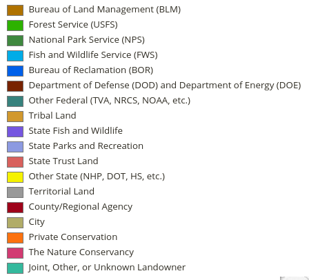
PAD-US contains data developed by many stewards, including federal agencies, state-focused agencies and organizations, and national nongovernmental organizations – learn more about the USGS PAD-US partners program here.
Here’s a summary illustration of the current state of PAD-US data. Access a map view and a PDF report for steward agencies below – federal agencies are in the table, on the map below that click on any state for a more detailed view of that state’s data. Note that the ranking of “complete” means between 95 and 100 percent complete – all ranks are general estimates.
- Federal Data Stewards – federal land managers include the Bureau of Land Management, National Park Service, Fish & Wildlife Service, U.S. Forest Service, Army Corps of Engineers, Bureau of Reclamation, Bureau of Indian Affairs, NOAA and others, who all collaborate on data sharing into PAD-US. Learn more about the Federal Lands Working Group »
- State Data Stewards are agencies, universities or nonprofits who oversee collections of state and local information on protected areas. Currently, 30 states have defined steward organizations of varying capacities. Learn more about the USGS State Stewards program »
- National NGO Data Stewards include The Nature Conservancy, the Trust for Public Land and Ducks Unlimited (these latter two also lead the National Conservation Easement Database (NCED) which provides easement data to PAD-US and is partly supported by USGS GAP), plus others. Read more about the PAD-US NGO Working Group and download fact sheet (scroll down to bottom of page)»
FEDERAL DATA STEWARDS AND COMPLETENESS STATUS
14 federal agencies contribute land, water, and boundary information to PAD-US. Individual federal agency completeness estimates below balance acres inventoried and quality of data/attributes in each inventory, including fee parcels, easement interests and major designations:
| National Park Service | — | Natural Resources Conservation Service | — |
| Forest Service | — | Department of Energy | — |
| Fish and Wildlife Service | — | Agricultural Research Service | — |
| Bureau of Land Management | — | Tennessee Valley Authority | — |
| Army Corps of Engineers | — | Bureau of Ocean Energy Management | — |
| Department of Defense | — | National Oceanic and Atmospheric Administration | — |
| Bureau of Reclamation | — | Census Bureau | — |
NONPROFIT STEWARDS
National nonprofits collaborate with USGS to leverage resources and contribute elements of projects for PAD-US:
- The Nature Conservancy (TNC) – provides national data on TNC holdings as well as data coordination with other TNC
- Trust for Public Land (TPL) – provides data on urban parks, and from the TPL Conservation Almanac
- Ducks Unlimited (DU) – provides data on DU holdings and other associated data
- For other NGO partners, see the USGS PAD-US data partners page.
TPL and Ducks Unlimited also lead the National Conservation Easement Database which provides this data to PAD-US.
STATE DATA STEWARDS AND STATUS
Use the visualization below to explore for state stewards: Completeness is the estimate of the degree to which all fee simple protected areas are inventoried for the state, plus qualitative consideration for overall accuracy (alignment, attribute completion) of the data. Estimates of easement inventory completion are available from the National Conservation Easement Database. Update Year is the most recent year a state’s data was updated in PAD-US or the year an update is expected (not all states can be updated every year). Capacity is a qualitative indication of the programmatic robustness of the State Steward’s ability to support PAD-US updates (data availability, consistency, budget, commitment, etc.).

